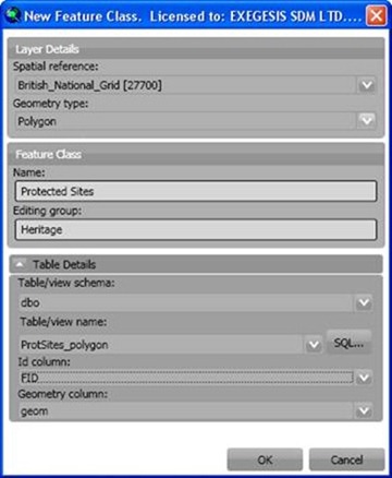
The New… and Edit... buttons on the Feature Class Admin form both open this form for creating/editing feature classes.

Spatial Reference
The spatial reference of the map will be selected by default, but can be changed if required. Select or browse to the required spatial reference. We recommend using the browse function, as the list is very long and take a while to load.
Geometry type
Select the geometry type for the new feature class. This cannot be altered for existing feature classes.
Feature Class Name
Specify a name for the new feature class. This can be the same as the table/view name, or can be an alias. This name will be the default when the data is shown as a layer in ArcMap. The form will not let you use the name of a feature class that already exists in the database. If you need to replace an existing feature class, first remove the existing feature class using the Feature Class Admin tools.
Editing group
If you want to group this layer with other layers for editing purposes, enter the name of the group.
Table/view schema
This pick-list shows schema in the database from which you can select an existing table or view. The default schema of the connecting user will be selected by default, but can be changed if required.
Existing tables/views in schema
This pick-list shows all tables and views in the selected schema. Select an existing table or view, or use the SQL… button to create a new view.
Id column
GISquirrel needs to know which column contains a unique record identifier. This will be automatically detected from the select table/view if possible, but the selection can be changed if required.
Geometry column
GISquirrel needs to know which column contains the feature shape/geometry information. This will be automatically detected from the select table/view if possible, but the selection can be changed if required.
OK / Cancel
On clicking “OK” a new record will be added to the "arcsquirrelmetadata" table, and the form will close returning you to the Feature Class Admin form.
Modified 2/20/2013